TOP PRIORITY FOR IMMEDIATE BROADCAST
TROPICAL CYCLONE ADVICE NUMBER 9
Issued at 8:52 pm WST on Sunday 24 February 2013
A Cyclone WARNING is current for coastal areas from Broome to Whim Creek,
including Port Hedland.A Cyclone WATCH is current for coastal areas from Whim Creek to Mardie
including Karratha and Dampier and extending inland to Marble Bar and Millstream
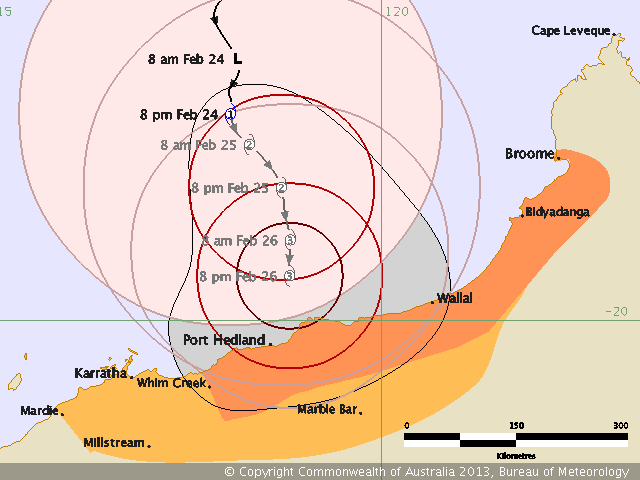
At 8:00 pm WST
Tropical Cyclone Rusty, Category 1 was estimated to be
330 kilometres north of Port Hedland and
445 kilometres west of Broome and
moving south at 6 kilometres per hour.
Tropical Cyclone Rusty is moving slowly towards the coast. Gales are expected
on the coast overnight between Wallal and Whim Creek and then extending north
to Broome during Monday.
Further intensification is likely as the cyclone approaches the coast on Monday
and Tuesday and there is a high risk that it will cross the coast as a severe
tropical cyclone. However, the slow motion of the cyclone means that the
crossing time and location is uncertain.
Rusty is a large tropical cyclone and its slow movement should result in higher
than usual rainfall in the Pilbara and western Kimberley. Very heavy rainfall
is expected in near coastal parts of the eastern Pilbara and western Kimberley
on Monday. During Tuesday and Wednesday widespread heavy rainfall is likely to
lead to major flooding in the De Grey catchment. Significant flooding in the
Fortescue is also likely.
DFES State Emergency Service (SES) advises of the following community alerts:
BLUE ALERT: People in communities between Broome and Whim Creek need to prepare
for cyclonic weather and organise an emergency kit including first aid kit,
torch, portable radio, spare batteries, food and water.
People between Whim Creek and Mardie and inland parts of the central and
eastern Pilbara should listen for the next advice.
Details of Tropical Cyclone Rusty at 8:00 pm WST:
.Centre located near...... 17.4 degrees South 118.1 degrees East
.Location accuracy........ within 35 kilometres
.Recent movement.......... towards the south at 6 kilometres per hour
.Wind gusts near centre... 120 kilometres per hour
.Severity category........
1.Central pressure.........
985 hectoPascalsThe next advice will be issued by 12:00 am WST Monday 25 February.
Cyclone advices and State Emergency Service Community Alerts are available by
dialling 1300 659 210
 20 Respuestas
 18419 Vistas