Huracán IAN Cat.4 (09-L. Islas Antillas - Mar Caribe - GOM- Florida)

Desconectado Pepeavilenho

  • Meteo Tropical
  • Supercélula
  • *****
  • 9070
  • Sexo: Masculino
    • Historia y Clima de Ávila
Huracán IAN Cat.4 (09-L. Islas Antillas - Mar Caribe - GOM- Florida)
« en: Martes 20 Septiembre 2022 16:27:16 pm »
Futura Hermine, cuidadito en el caribe

2. Central Tropical Atlantic:
A tropical wave located several hundred miles east of the Windward
Islands is producing a broad area of disorganized showers and
thunderstorms while moving westward at 15-20 mph.  Gradual
development of this system is forecast during the next several days
as the system approaches the Windward Islands, and a tropical
depression could form by the latter part of this week as the system
moves into the eastern and central Caribbean sea.
* Formation chance through 48 hours...low...10 percent.
* Formation chance through 5 days...medium...50 percent.


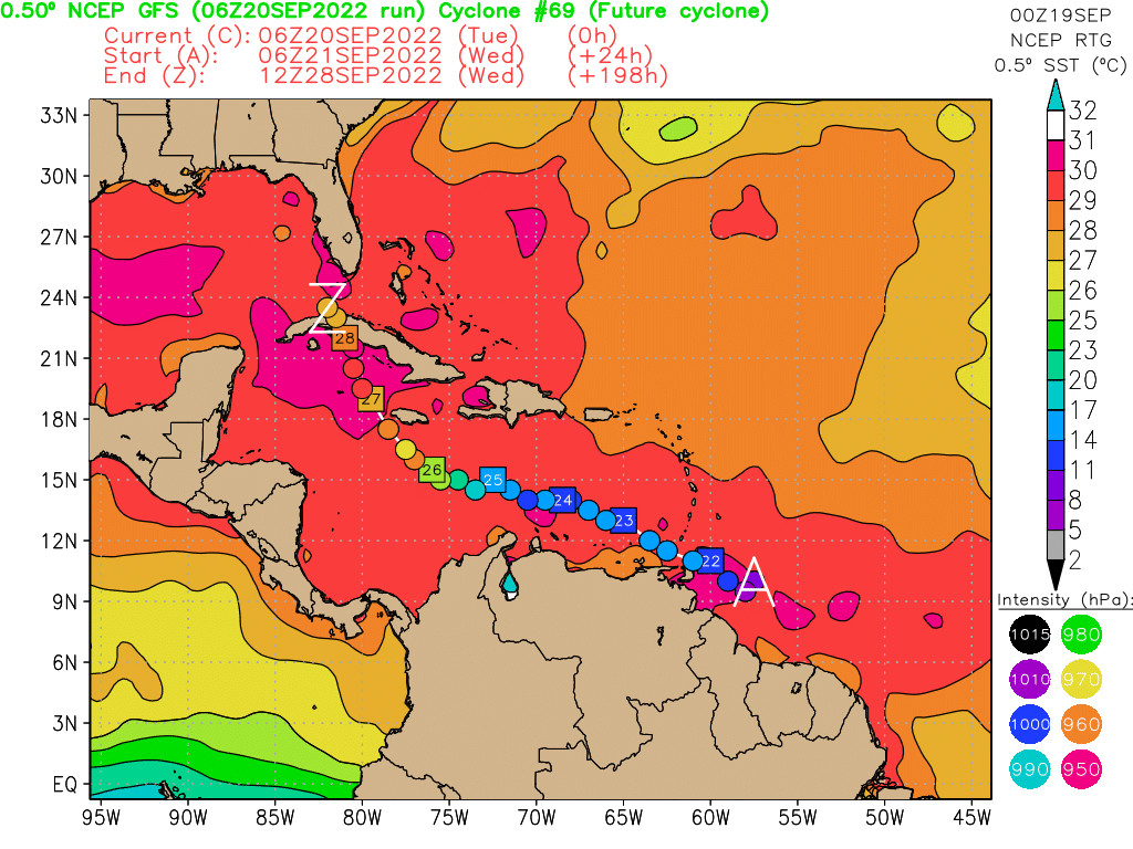
Europeo la mete por Yucatán. Mucho plazo aún, iremos viendo [emoji41]
« Última modificación: Miércoles 28 Septiembre 2022 14:34:17 pm por gdvictorm »

Desconectado rayo_cruces

  • Meteo Tropical
  • Supercélula
  • *****
  • 6564
  • Sexo: Masculino
  • "The long black cloud it`s coming down..."
Re:Huracán IAN Cat.2 (09-L. Islas Antillas - Mar Caribe - G. Mex - FLA.)
« Respuesta #1 en: Miércoles 21 Septiembre 2022 03:38:27 am »
Mosqueado me tiene.....

Que el horno no está para galleticas y los modelos lucen bastante amenazantes para mi. :cold:

Ya está en rojo.

Citar
Centro del Atlántico tropical:
Una onda tropical está produciendo actividad de lluvia y tormenta
eléctricas a unos cientos de millas al este de las Islas de Barlovento.
El sistema continúa mostrando signos de organización y probablemente se
convierta en una depresión tropical dentro de los próximos dos o tres días.
Se pronostica que el disturbio se moverá hacia el oeste noroeste a través de
las Islas del sur de Barlovento tarde el miércoles y luego se moverá hacia el
centro del Mar Caribe tarde esta semana. Intereses en las Islas de Barlovento
deben monitorear de cerca el progreso de este sistema ya que fuertes lluvias
y vientos ráfagas podrían afectar estas islas comenzando el miércoles.
• Probabilidad de formación en 48 horas...alta..70 por ciento.
• Probabilidad de formación en 5 días...alta..90 por ciento..

Faltan muchos días pero los modelos están bastante de acuerdo en hacerme la visita. Ojalá fallen.

Saludos 8)

Enviado desde mi 5028A mediante Tapatalk
« Última modificación: Miércoles 21 Septiembre 2022 03:40:03 am por rayo_cruces »
CRUCES, Cienfuegos, CUBA 22º 20`N; 80º 16`W; 90-100 msnm
Lluvia Med. Hist 1456 mm Temp. Seca(nov-abril) 288mm Temp Lluv.(may-oct) 1200mm, Record Hist diario: 1 Jun 1988 aprox 500mm
Temperaturas   Med. anual 25.3ºC  Feb. 20.7ºC Julio 28.2ºC  Max. 36.2ºC 02/05/09 Min. 6.2ºC 15/12/10
Desde el centro de Cuba donde tenemos rayos a montones y algún tornadito además de los huracanes que todos conocen.

Desconectado gdvictorm

  • Administrador/a
  • Supercélula Tornádica
  • *****
  • 12448
  • Sexo: Masculino
  • Ávila 19-mayo-2007 (tornado NSP, Valle Amblés)
Re:Huracán IAN Cat.2 (09-L. Islas Antillas - Mar Caribe - G. Mex - FLA.)
« Respuesta #2 en: Jueves 22 Septiembre 2022 00:13:58 am »
Pues efectivamente, aunque aún es poca cosa, tiene una pinta muy peligrosa para el Caribe, Golfo de México oriental y todo lo que pille en medio (Cuba y Florida especialmente). La cizalladura en esa zona va a ser baja, el mar está a 30ºC y el aire seco va a estar bastante contenido, al menos al principio.

De momento la onda tiene una convección poco organizada y no tiene buenas condiciones por delante estas próximas 12-24 horas. Pero después el entorno empezará a ser favorable.


saludos.
San Martín de la Vega del Alberche (1524msnm)
Ávila . Zona Norte (1130msnm)
Zaratán (Valladolid)  (750msnm)

Desconectado Torrelloviedo

  • La vieja guardia de Meteored
  • Supercélula Tornádica
  • *****
  • 17619
  • Sexo: Masculino
Re:Huracán IAN Cat.2 (09-L. Islas Antillas - Mar Caribe - G. Mex - FLA.)
« Respuesta #3 en: Jueves 22 Septiembre 2022 10:26:04 am »
Mmmm, como está el contenido de calor en capas más bajas. El OHC y tal...

Hay bucle de Eddy libre por el GOM?  Eso de cara a majors, es importante.

Y pinta a Major tocando Cuba y entrando en el Golfo
Oviedo Este (180m)

Oviedo Observatorio (336m)

Desconectado rayo_cruces

  • Meteo Tropical
  • Supercélula
  • *****
  • 6564
  • Sexo: Masculino
  • "The long black cloud it`s coming down..."
Re:Huracán IAN Cat.2 (09-L. Islas Antillas - Mar Caribe - G. Mex - FLA.)
« Respuesta #4 en: Viernes 23 Septiembre 2022 06:08:02 am »
Sigue pintando muy mal para acá, los modelos se han movido entre Yucatán y Cuba con cada salida pero parece casi seguro que en 24 - 48 horas tendremos una nueva depresión tropical en el Caribe central.

En las imágenes de satélite se intuye ya un giro en capas bajas mientras de momento la convención se desplaza al sur gracias a la cizalladura que genera en el área un chorro en altura generado por un ramal del outflow de FIONA dirigido al sur.

Los parámetros oceánicos son ideales y con que solo baje la cizalladura ya tenemos un problema en ciernes.

Saludos 8)

Enviado desde mi 5028A mediante Tapatalk

« Última modificación: Viernes 23 Septiembre 2022 06:11:02 am por rayo_cruces »
CRUCES, Cienfuegos, CUBA 22º 20`N; 80º 16`W; 90-100 msnm
Lluvia Med. Hist 1456 mm Temp. Seca(nov-abril) 288mm Temp Lluv.(may-oct) 1200mm, Record Hist diario: 1 Jun 1988 aprox 500mm
Temperaturas   Med. anual 25.3ºC  Feb. 20.7ºC Julio 28.2ºC  Max. 36.2ºC 02/05/09 Min. 6.2ºC 15/12/10
Desde el centro de Cuba donde tenemos rayos a montones y algún tornadito además de los huracanes que todos conocen.

Desconectado Pepeavilenho

  • Meteo Tropical
  • Supercélula
  • *****
  • 9070
  • Sexo: Masculino
    • Historia y Clima de Ávila
Re:Huracán IAN Cat.2 (09-L. Islas Antillas - Mar Caribe - G. Mex - FLA.)
« Respuesta #5 en: Viernes 23 Septiembre 2022 10:03:42 am »
Tenemos la 9ª DT de la temporada, afectada por la cizalladura procedente de la circulación de Fiona
Pero vamos, que en breves va a comenzar el espectáculo
Hasta donde quiera, antes de tocar tierra en Cuba, según parece

Desconectado Pepeavilenho

  • Meteo Tropical
  • Supercélula
  • *****
  • 9070
  • Sexo: Masculino
    • Historia y Clima de Ávila
Re:Huracán IAN Cat.2 (09-L. Islas Antillas - Mar Caribe - G. Mex - FLA.)
« Respuesta #6 en: Sábado 24 Septiembre 2022 09:05:38 am »
The depression is upgraded to
Tropical Storm Ian with 35-kt winds.

Intensification is expected to be gradual during the next
36 hours while Ian gets better organized in a lower-shear
environment, but after that time, conditions will be conducive for
faster strengthening.
  In fact, the NHC intensity forecast
explicitly calls for rapid intensification (RI) between days 2 and
3 while Ian is moving over the northwestern Caribbean Sea toward
western Cuba.  It's worth nothing too that the RI indices from
SHIPS are showing a 2-in-3 chance of a 65-kt increase in winds
during the next 3 days
, and if that transpires, Ian could be
stronger than what's shown in the official forecast.

Va a rozar la Cat.5 antes de tocar tierra este cabrón :rcain:

Desconectado rayo_cruces

  • Meteo Tropical
  • Supercélula
  • *****
  • 6564
  • Sexo: Masculino
  • "The long black cloud it`s coming down..."
Re:Huracán IAN Cat.2 (09-L. Islas Antillas - Mar Caribe - G. Mex - FLA.)
« Respuesta #7 en: Sábado 24 Septiembre 2022 19:38:54 pm »
IAN aún está en etapa formativa pero ya luce como un futuro potente ciclón tropical. Aunque aún hay cizalladura del NE ya el centro comienza a estar cubierto de la nubosidad densa central (CDO) y empiezan a formarse las bandas espirales .

Con condiciones casi ideales por delante a partir de mañana el tope de intensidad y cuan rápido llegue a ahí es difícil de predecir. En cuanto a trayectorias los modelos van comenzando a agruparse juntos y además algo más al oeste en cada salida de forma que IAN solo tocaría directamente el extremo occidental de Cuba mientras gana rápidamente en intensidad (recuerdo a MICHAEL en 2018, lo rápido que ganó intensidad sobre el canal de Yucatán muy cerca del cabo de San Antonio).


Saludos 8)

Enviado desde mi 5028A mediante Tapatalk
« Última modificación: Sábado 24 Septiembre 2022 19:41:12 pm por rayo_cruces »
CRUCES, Cienfuegos, CUBA 22º 20`N; 80º 16`W; 90-100 msnm
Lluvia Med. Hist 1456 mm Temp. Seca(nov-abril) 288mm Temp Lluv.(may-oct) 1200mm, Record Hist diario: 1 Jun 1988 aprox 500mm
Temperaturas   Med. anual 25.3ºC  Feb. 20.7ºC Julio 28.2ºC  Max. 36.2ºC 02/05/09 Min. 6.2ºC 15/12/10
Desde el centro de Cuba donde tenemos rayos a montones y algún tornadito además de los huracanes que todos conocen.

Desconectado rayo_cruces

  • Meteo Tropical
  • Supercélula
  • *****
  • 6564
  • Sexo: Masculino
  • "The long black cloud it`s coming down..."
Re:Huracán IAN Cat.2 (09-L. Islas Antillas - Mar Caribe - G. Mex - FLA.)
« Respuesta #8 en: Domingo 25 Septiembre 2022 14:25:44 pm »
IAN aún está en formación, del NHC nos cometan que el último RECON encontró que aún el centro en superficie está desplazado al sur respecto al centro en niveles medios, lo que ha hecho que aún IAN  no "despegue" debido a esta falta de alineación del sistema en la vertical.

Ahora, una vez que esto suceda las posibilidades de tener una RI son muy grandes, sobre el 90% según los indicadores para ello así como el giro al NW. Así que en las próximas horas tendremos a IAN moviéndose al NW sobre el NW del Caribe experimentando una RI que lo debe elevar al status de mayor en 24 horas.

Saludos 8)

Enviado desde mi 5028A mediante Tapatalk

CRUCES, Cienfuegos, CUBA 22º 20`N; 80º 16`W; 90-100 msnm
Lluvia Med. Hist 1456 mm Temp. Seca(nov-abril) 288mm Temp Lluv.(may-oct) 1200mm, Record Hist diario: 1 Jun 1988 aprox 500mm
Temperaturas   Med. anual 25.3ºC  Feb. 20.7ºC Julio 28.2ºC  Max. 36.2ºC 02/05/09 Min. 6.2ºC 15/12/10
Desde el centro de Cuba donde tenemos rayos a montones y algún tornadito además de los huracanes que todos conocen.

Desconectado rayo_cruces

  • Meteo Tropical
  • Supercélula
  • *****
  • 6564
  • Sexo: Masculino
  • "The long black cloud it`s coming down..."
Re:Huracán IAN Cat.2 (09-L. Islas Antillas - Mar Caribe - G. Mex - FLA.)
« Respuesta #9 en: Lunes 26 Septiembre 2022 05:26:42 am »
Finalmente IAN ha comenzado a ganar intensidad, ha echado un día para organizarse tras la disminución de la cizalladura, y ahora moviéndose al noroeste y ganando en intensidad sará un muy mal visitante a los lugares que llegue.

Citar
Tropical Storm Ian Advisory Number  12
NWS National Hurricane Center Miami FL       AL092022
1100 PM EDT Sun Sep 25 2022

...IAN CONTINUES TO STRENGTHEN...
...EXPECTED TO PRODUCE SIGNIFICANT WIND AND STORM SURGE IMPACTS
IN WESTERN CUBA...


SUMMARY OF 1100 PM EDT...0300 UTC...INFORMATION
-----------------------------------------------
LOCATION...17.3N 81.4W
ABOUT 140 MI...225 KM S OF GRAND CAYMAN
ABOUT 390 MI...630 KM SE OF THE WESTERN TIP OF CUBA
MAXIMUM SUSTAINED WINDS...65 MPH...100 KM/H
PRESENT MOVEMENT...NW OR 315 DEGREES AT 13 MPH...20 KM/H
MINIMUM CENTRAL PRESSURE...989 MB...29.21 INCHES


DISCUSSION AND OUTLOOK
----------------------
At 1100 PM EDT (0300 UTC), the center of Tropical Storm Ian was
located near latitude 17.3 North, longitude 81.4 West.  Ian is
moving toward the northwest near 13 mph (20 km/h).  A turn toward
the north-northwest is expected on Monday followed by a northward
motion on Tuesday with a slightly slower forward speed.  On the
forecast track, the center of Ian is expected to pass near or west
of the Cayman Islands on Monday, and near or over western Cuba
Monday night and early Tuesday.  Ian will then emerge over the
southeastern Gulf of Mexico on Tuesday.

Maximum sustained winds have increased to near 65 mph (100 km/h)
with higher gusts.  Additional strengthening is forecast tonight,
followed by more rapid strengthening on Monday and Tuesday.  Ian is
forecast to become a hurricane by early Monday and a major
hurricane on Tuesday.

Tropical-storm-force winds extend outward up to 70 miles (110 km)
from the center.

The minimum central pressure estimated from NOAA Hurricane Hunter
observations is 989 mb (29.21 inches).


HAZARDS AFFECTING LAND
----------------------
Key messages for Ian can be found in the Tropical Cyclone Discussion
under AWIPS header MIATCDAT4 and WMO header WTNT44 KNHC and on the
web at hurricanes.gov/text/MIATCDAT4.shtml.

WIND:  Hurricane conditions are expected to reach Grand Cayman on
Monday, with tropical storm conditions beginning late tonight.
Hurricane conditions are expected within the warning area in Cuba by
early Tuesday, with tropical storm conditions expected by late
Monday.

Tropical storm conditions are expected within the tropical storm
warning area in Cuba Monday night and Tuesday.  Tropical storm
conditions are possible on Little Cayman and Cayman Brac on Monday.

Tropical storm conditions are expected in the warning area in the
lower Florida Keys on Tuesday.  Tropical storm conditions are
possible within the watch area along the Florida west coast by
Tuesday evening.

RAINFALL:  Ian is expected to produce the following rainfall:

Jamaica: Additional 1-3 inches, with storm total local maxima up to
8 inches.

Cayman Islands: 3 to 6 inches, with local maxima up to 8 inches.

Western Cuba: 6 to 10 inches, with local maxima up to 16 inches.

Florida Keys into southern and central Florida Peninsula: 2 to 4
inches, with local maxima up to 6 inches beginning Monday through
Wednesday evening.

Heavy rainfall may affect North Florida, the Florida Panhandle and
portions of the Southeast on Thursday, Friday and Saturday.

These rains may produce flash flooding and mudslides in areas of
higher terrain, particularly over Jamaica and Cuba. Considerable
flooding impacts are possible later this week in west central
Florida given already saturated antecedent conditions, and flash and
urban flooding is possible with rainfall across the Florida Keys and
the Florida peninsula through mid week.  Additional flooding and
rises on area streams and rivers across northern Florida and parts
of the Southeast later this week cannot be ruled out.

STORM SURGE:  The combination of storm surge and the tide will
cause normally dry areas near the coast to be flooded by rising
waters moving inland from the shoreline.  The water could reach the
following heights above ground somewhere in the indicated areas if
the peak surge occurs at the time of high tide...

* Englewood to Bonita Beach, FL... 4-7 ft
* Bonita Beach to East Cape Sable, FL... 3-5 ft
* East Cape Sable to Card Sound Bridge, FL including Florida Bay...
2-4 ft
* Florida Keys including the Dry Tortugas... 2-4 ft

The deepest water will occur along the immediate coast near and to
the right of the center, where the surge will be accompanied by
large waves.  Surge-related flooding depends on the relative timing
of the surge and the tidal cycle, and can vary greatly over short
distances.  For information specific to your area, please see
products issued by your local National Weather Service forecast
office.

Storm surge could raise water levels by as much as 9 to 14 feet
above normal tide levels along the coast of western Cuba in areas
of onshore winds in the hurricane warning area Monday night
and early Tuesday.

Storm surge could raise water levels by as much as 2 to 4 feet above
normal tide levels along the immediate coast in areas of onshore
winds in the Cayman Islands Sunday night into Monday.

SURF:  Swells generated by Ian are affecting Jamaica and the Cayman
Islands. Swells will spread northwestward to the southwestern coast
of Cuba and the coasts of Honduras, Belize, and the Yucatan
Peninsula of Mexico on Monday and Monday night. These swells are
likely to cause life-threatening surf and rip current conditions.
Please consult products from your local weather office.

Forecaster Pasch

Ya tiene vientos máximos sostenidos de 100Km/h y presión central mínima de 989 Hp, comentar que en 6 horas la presión ha bajado 14Hp. Pinar del Rio, la provincia mas occidental de Cuba recibirá el imparto en unas 24 horas de un huracán de gran intensidad posiblemente aun en plena RI, (la  última vez con GUSTAV en 2008 casi en el limite de la Categoría 5). Mas tarde, para jueves es muy probable que la Florida reciba el impacto de ya un huracán intenso y con un campo de vientos aun mayor, ojo con la marea de tormenta.

Saludos 8)
CRUCES, Cienfuegos, CUBA 22º 20`N; 80º 16`W; 90-100 msnm
Lluvia Med. Hist 1456 mm Temp. Seca(nov-abril) 288mm Temp Lluv.(may-oct) 1200mm, Record Hist diario: 1 Jun 1988 aprox 500mm
Temperaturas   Med. anual 25.3ºC  Feb. 20.7ºC Julio 28.2ºC  Max. 36.2ºC 02/05/09 Min. 6.2ºC 15/12/10
Desde el centro de Cuba donde tenemos rayos a montones y algún tornadito además de los huracanes que todos conocen.

Desconectado Torrelloviedo

  • La vieja guardia de Meteored
  • Supercélula Tornádica
  • *****
  • 17619
  • Sexo: Masculino
Re:Huracán IAN Cat.2 (09-L. Islas Antillas - Mar Caribe - G. Mex - FLA.)
« Respuesta #10 en: Lunes 26 Septiembre 2022 10:07:52 am »
Tiene toda la pinta de RI viendo el excelente outflow que se observa en el satélite...
Oviedo Este (180m)

Oviedo Observatorio (336m)

Desconectado Pepeavilenho

  • Meteo Tropical
  • Supercélula
  • *****
  • 9070
  • Sexo: Masculino
    • Historia y Clima de Ávila
Re:Huracán IAN Cat.2 (09-L. Islas Antillas - Mar Caribe - G. Mex - FLA.)
« Respuesta #11 en: Lunes 26 Septiembre 2022 15:00:03 pm »
IAN ya es Huracán

65kts-981mb


Pico de 120kts en 48h, se me hace corto.